Saturday, January 5, 2013


Contents |
Coordinates & Location type
- Latitude: 27.91667
- Longitude:84.25
- Latitude (DMS):27° 55' 0 N
- Longitude (DMS):84° 15' 0 E
Village Development Committees (VDCs)

- Ambukhaireni
- Arunodaya
- Baidi
- Bandipur
- Barbhanjyang
- Basantapur
- Bhanu
- Bhanumati
- Bhimad
- Bhirkot
- Byas
- Chhang
- Chhimkeswori
- Chhipchhipe
- Chok Chisapani
- Damauli
- Deurali
- Devghat
- Dharampani
- Dhorphirdi
- Dulegaunda
- Firfire
- Gajarkot
- Ghansikuwa
- Jamune Bhanjyang
- Kabilas
- Kahu Shivapur
- Keshavtar
- Khairenitar
- Kihun
- Kota
- Kotdarbar
- Kyamin
- Majhakot
- Manpang
- Pokhari Bhanjyang
- Purkot
- Raipur
- Ramjakot
- Ranipokhari
- Risti
- Rupakot
- Samungbhagawati
- Satiswara
- Sundhara
- Syamgha
- Tanahunsur
- Thaprek
- Mirlung
Map Of Tanahu
http://www.un.org.np/maps/district-maps/western/Tanahu.pdfSee also
References
- Districts of Nepal at statoids.com


| This Nepali location article is a stub. You can help Wikipedia by expanding it. |
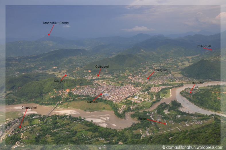
Damauli is the headquarters of Tanahu District in the Gandaki Zone of central Nepal. At the time of the 1991 Nepal census
it had a population of 18,099 people residing in 3604 individual
households.It's one of the well planned towns in Nepal.It's a fast
growing city. Majority of the population are engaged in some kind of
business. It is easily recognizable because it is located on the
confluence of two major rivers the Madi and the Seti. The Manung hill is
another important geographical landmark overlooking the Town. It is one
of the well planned town of Nepal. [1]
References
- ^ "Nepal Census 2001", Nepal's Village Development Committees (Digital Himalaya), retrieved 24 December 2012.
External links
- UN map of the municipalities of Tanahu District
- Before it was categorized as village development committee but before approximately 16 years it has been categorized as Vyas Municipality.
| This Gandaki Zone location article is a stub. You can help Wikipedia by expanding it. |
|
|||||||||||

Friday, January 4, 2013
damauli
| Damauli | |
|---|---|
| Country | |
| Zone | Gandaki Zone |
| District | Tanahu District |
| Population (2001) | |
| • Total | 30,000 estimated |
| Time zone | Nepal Time (UTC+5:45) |
| Postal code | 33900 |
| Area code(s) | 065 |
References
- ^ "Nepal Census 2001", Nepal's Village Development Committees (Digital Himalaya), retrieved 24 December 2012.
External links
- UN map of the municipalities of Tanahu District
- Before it was categorized as village development committee but before approximately 16 years it has been categorized as Vyas Municipality.
| This Gandaki Zone location article is a stub. You can help Wikipedia by expanding it. |
|
Capital: Damauli
|
||
|
| ||
Subscribe to:
Posts (Atom)